“I want to plan an expedition but I don’t know where to start”
The above statement is one of the more common themes that arises when people contact me for help. They have an idea but are slightly overwhelmed about starting something – a bike ride, a climbing expedition, a polar journey – with which they have no prior experience.
The first bit of advice has always got to be to just start. There is no particular ‘right way’ of doing these things and, in reality, planning an expedition to the South Pole is no different from any other project – you just write down a list of things that need doing, you start doing them and then you add to that list as you go along.
However, technology can sometimes make things a little easier. As such, I’ve produced a brief list of the key bits of software that I use when planning my expeditions, or indeed managing an expedition for someone else.
You’ll see that most of them are pretty obvious. You already knew about Google Maps? No surprise but that doesn’t mean it’s not still a top tool for planning a trip. If you’re planning something a bit more complicated then scroll down further and read about PB Works and Base Camp.
[divide]
Google Maps
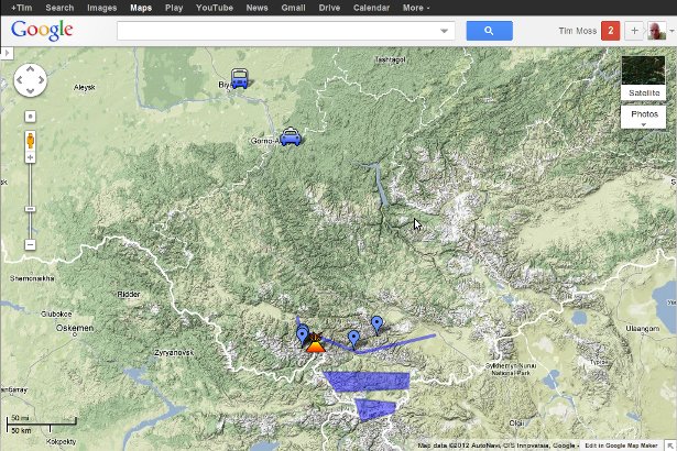
It’s obvious but brilliant. Many of my ideas for expeditions come from playing around on Google Maps. It’s a good place to start for finding things to walk/cycle across, measuring distances from A to B, and marking airports and mountains to get an overview of where you’re heading.
The ability to share the map with other people, even make it publicly available, is really useful.

[divide]
Google Earth
This software is so good that it can almost take away some of the magic of visiting a place for the first time. If you tilt the view and zoom in to get a 3D perspective then it’s fantastic for scoping out a suitable location for a base camp, picking a good route through mountains or finding a suitable place to land a kayak.
We took Google Earth print-outs when climbing in the Russian Altai which we used to see what peaks lay around the corner of the valley in which we’d camped and to plan lines of attack up new mountains. We also took a satellite view of the Wahiba Sands when we walked across them as it showed us how many dunes there – much better than a featureless map.

(Photo from Digital Earth blog)
Google Docs (now called ‘Drive’)
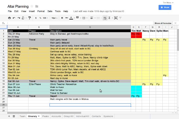
I’ve always enjoyed a good plan or spreadsheet to kick start my expeditions and a Google Doc is my preferred choice these days. Being omnipresent online is useful when on the move (and perhaps even in the field now as technology makes that easier) but the best feature is being able to collaborate: compiling useful links, updating a shared budget and adding passport details for group visa applications.
Being able to update a communal document also saves on endless email conversations and unnecessary CCing.
I either use a plain Document for collating research and writing ideas, or a Spreadsheet with lots of tabs for itineraries, budgets and team details.

[divide]
PB Works
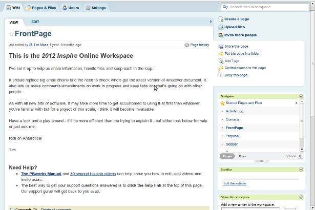
When a project gets bigger or more complicated than the simplicity of a Google Doc allows then I look to PB Works. It’s a free, online work space. You can create a series of pages (e.g. Kit, Sponsorship, Itinerary) which are viewed and edited online, and navigated using a simple system, and upload any documents (e.g. the latest version of your sponsorship proposal). The contents are private to you and any users you choose to add (e.g. team-mates).
If you’re using it for commercial purposes then you need to pay a fee but if you’re just planning an expedition or similar then it’s entirely free and with very few restrictions.
I started using this when working for the Kaspersky Commonwealth Antarctic Expedition, used it to manage my 2012 Inspire project, and set up a wiki for Sarah Outen’s London-2-London via the World Expedition. A great piece of kit for keeping tabs on a complicated expedition.

[divide]
Basecamp
Another very popular piece of online project management software is Basecamp. Unlike PB Works, you have to pay for a licence to use Basecamp but if you’re working with a budget then it’s worth a look.
[divide]
PathWrangler
Software specifically designed for planning travel and expeditions. Recommended in the comments below, I’ve not used it personally but it looks like just the sort of thing.
What tools do you use for planning your expeditions? Have you got any experience with these pieces of software? Share your thoughts in the comments section below.
What do you think? Please do add your thoughts below…